10 Pembroke Pines neighborhoods from Chapel Trail to Pines Village: ZIP codes, zoned schools with 2026 state grades, and August 2026 Zillow values.
Last checked Oct. 10, 2026. Sources: the Broward County Property Appraiser’s neighborhood layer, published by Broward County GIS; Broward County’s city boundaries, address points and 2025-26 school boundaries; the City of Pembroke Pines’ planning maps; the Florida Department of Education’s 2026 school grades; Zillow Research; the Census Bureau; and OpenStreetMap.
Pembroke Pines is a city of 173,194 people in southwest Broward County, according to the Census Bureau’s 2020-2024 American Community Survey. It covers about 35 square miles in a long strip, about 14 miles from Florida’s Turnpike on the east to U.S. 27 at the edge of the Everglades on the west, and less than 3 miles from north to south for most of that length. Pembroke Road, the line with Miramar, is the southern edge for most of the way, and Sheridan Street the northern one. Pines Boulevard runs nearly the whole length of the city and I-75 crosses it in the middle. Most homes are in named neighborhoods: about 92% of the city’s street addresses fall inside one of the Property Appraiser’s neighborhood outlines.
Three things to know before you look at a listing:
- Seven main ZIP codes. Of about 40,100 street addresses inside the city in Broward County’s address data, 23% are in 33029 and 20% in 33028, both west; 17% in 33024 and 14% in 33026, in the middle and east; and 12% in 33025, 8% in 33027 and 5% in 33023, along the south side. Zillow files 33023, 33025 and 33027 under Miramar, which shares them.
- Four high school zones. In Broward County’s 2025-26 school boundary data, 50% of addresses in the city are zoned for Charles W. Flanagan High, 26% for West Broward High, 18% for McArthur High, which is in Hollywood, and 6% for Everglades High, which is in Miramar. School zones do not follow city limits or ZIP codes; always check one address with the district’s Find My School tool.
- Two public school systems. Broward County Public Schools runs the zoned schools, and the City of Pembroke Pines runs its own charter schools, which families apply to separately. See our schools guide.
The areas at a glance
Typical home value is the Zillow Home Value Index for the area’s ZIP code in August 2026: a modeled typical value for the middle third of homes, single-family homes and condos together, not a sale price. It is a ZIP code figure, so it is the same for every area in that ZIP code. School grades are the Florida Department of Education’s 2026 grades.
| Area | ZIP | Zoned high school (2026 grade) | Typical home value (ZIP) | Guide |
|---|---|---|---|---|
| Chapel Trail | 33029 | West Broward (A) | $710,785 | Chapel Trail |
| Silver Lakes | 33029 | West Broward (A) north of Pines Blvd., Everglades (A) south | $710,785 | Silver Lakes |
| Pembroke Isles | 33028 | West Broward (A) | $672,022 | Pembroke Isles |
| Spring Valley | 33028 | Charles W. Flanagan (A) | $672,022 | Spring Valley |
| Towngate | 33028 | Charles W. Flanagan (A) | $672,022 | Towngate |
| Pembroke Falls | 33028 | Charles W. Flanagan (A) | $672,022 | Pembroke Falls |
| Grand Palms | 33027 | Charles W. Flanagan (A) | $470,631 | Grand Palms |
| Pembroke Lakes | 33026 | Charles W. Flanagan (A) | $442,919 | Pembroke Lakes |
| Pasadena Lakes | 33024 | McArthur (C) | $473,138 | Pasadena Lakes |
| Pines Village | 33023 | McArthur (C) | $459,203 | Pines Village |
For comparison, the citywide Pembroke Pines figure was $488,121 in August 2026, down 1.9% from a year earlier. On the year, 33029 was down 0.6%, 33028 down 1.2%, 33027 down 2.8%, 33026 down 3.4%, 33024 down 1.7% and 33023 down 1.4%. More in our home prices guide.
Map of the areas
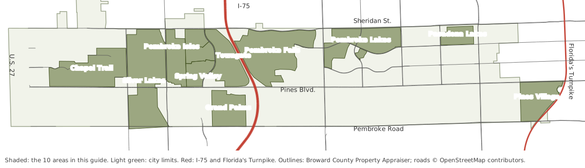
Map by Pembroke Pines Today. Neighborhood outlines are from the Broward County Property Appraiser’s neighborhood layer; city limits from Broward County GIS; roads © OpenStreetMap contributors.
The areas
Chapel Trail. The westernmost area in this guide, about 910 acres north of Pines Boulevard and west of NW 184th Avenue, with the most street addresses of any area here and the 450-acre Chapel Trail Nature Preserve at its north edge.
Silver Lakes. The largest neighborhood in the county’s records for the city, about 1,340 acres from Pembroke Road to Sheridan Street. Pines Boulevard splits it between two sets of school zones.
Pembroke Isles. About 400 acres east of NW 172nd Avenue, with Panther Run Elementary inside it and Silver Lakes Park North across the road.
Spring Valley. Two Spring Valley pieces and Parkside at Spring Valley, about 570 acres west of NW 160th Avenue, beside the city’s Dream Park.
Towngate. About 555 acres between NW 160th Avenue and I-75, north of Pines Boulevard, with Towngate Park and Silver Palms Elementary inside.
Pembroke Falls. About 1,140 acres east of I-75 up to Sheridan Street, next to the county’s C.B. Smith Park.
Grand Palms. About 470 acres south of Pines Boulevard between SW 160th Avenue and I-75, about 2.4 miles by road from exit 9.
Pembroke Lakes. About 770 acres between Flamingo Road and Palm Avenue, with its own elementary school and the city’s golf and tennis center at its edge, and the shortest drive to City Hall of any area here.
Pasadena Lakes. About 230 acres between Douglas Road and University Drive, the closest area in this guide to Fort Lauderdale-Hollywood International Airport by road.
Pines Village. About 510 acres in the east between North Perry Airport and Florida’s Turnpike, about 1.3 miles by road from Turnpike exit 49.
How Pembroke Pines compares with its neighbors on taxes, schools and home values: Pembroke Pines vs. Miramar vs. Southwest Ranches vs. Cooper City.
How we built this
We named only areas a public source places on a map. The sources were:
- The Broward County Property Appraiser’s neighborhood layer, published by Broward County GIS, which draws 74 named neighborhoods inside Pembroke Pines and records a homeowners association name for most of them. About 92% of the city’s street addresses fall inside one. We chose 10 large ones spread across the city and joined pieces that share a name; each area page says which pieces it includes. We left out Century Village, about 675 acres, because the county’s address data has no address points inside its outline to measure ZIP codes or school zones with.
- The city’s own maps. The City of Pembroke Pines’ maps page offers a commission district map labeled as showing neighborhoods; it shows aerial imagery and district lines but no neighborhood names, and we found no city list of neighborhoods. OpenStreetMap has no neighborhood place names inside the city.
- Broward County’s address points, about 40,100 inside the city, used for ZIP code shares, and its 2025-26 school boundary layers, updated March 2026, matched to every one of those addresses on Oct. 10. The district’s 2026-27 zones may differ; the Find My School tool is the final word.
- Distances measured on the OpenStreetMap road network with the OSRM routing engine; bus routes from Broward County Transit’s published schedule data for summer 2026; parks from Broward County’s parks layer and the city’s facility pages; stores from OpenStreetMap, © OpenStreetMap contributors.
- Photos are from Wikimedia Commons; where no ground-level photo of an area exists, we used a public domain 2021 aerial photograph from the U.S. Department of Agriculture.
We do not rank areas. Every figure on these pages is from a named public source; if you see one that is out of date, tell us on our corrections page.
Related: schools, home prices, property taxes, getting around, parks and trails and moving to Pembroke Pines.
Frequently asked questions
What are the neighborhoods in Pembroke Pines, Florida?
The Broward County Property Appraiser’s neighborhood layer names 74 neighborhoods inside the city. Our guide covers 10 of the largest: Chapel Trail, Grand Palms, Pasadena Lakes, Pembroke Falls, Pembroke Isles, Pembroke Lakes, Pines Village, Silver Lakes, Spring Valley and Towngate.
What ZIP codes are in Pembroke Pines?
Seven main ones. Of about 40,100 street addresses inside the city in Broward County’s address data, 23% are in 33029, 20% in 33028, 17% in 33024, 14% in 33026, 12% in 33025, 8% in 33027 and 5% in 33023. A few hundred more are in 33332 and 33331.
What high school is Pembroke Pines zoned for?
It depends on the address. In Broward County’s 2025-26 school boundary data, 50% of addresses in the city are zoned for Charles W. Flanagan High, 26% for West Broward High, 18% for McArthur High and 6% for Everglades High. Flanagan, West Broward and Everglades earned an A in Florida’s 2026 grades; McArthur earned a C.
Do Pembroke Pines ZIP codes include Miramar?
Some do. Zillow files 33023, 33025 and 33027 under Miramar, which shares them, so a figure for those ZIP codes is not a Pembroke Pines-only figure. The Broward County Property Appraiser’s property search shows which city a parcel is in.
What is the main road through Pembroke Pines?
Pines Boulevard runs east to west through nearly the whole city, from near Florida’s Turnpike to U.S. 27. I-75 crosses it in the middle of the city at exit 9.
Have your say